
EXPEDITION PREPARATION
AND PLANNING – PART ONE
There are many different ways we can plan for our DofE expeditions and this article highlights one of the more traditional methods; using route cards.
For the many of us being out on expedition is what we are live for and is often the section of DofE that we enjoy the most. As well as bringing the biggest challenge for the young people we work with.
What we must not forget is the hard work that goes on before we even step foot out of the door.
We at Mountain Water Expeditions have many years experience of working closely with DofE expedition groups in schools and colleges. Over that time have created some amazing resources and activity ideas which we will share in our next series of blogs. Hopefully these will make your expedition training easier to plan, and lead to a safe, enjoyable expedition season for yourself and your DofE expedition groups.
What are route cards?
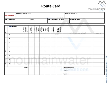
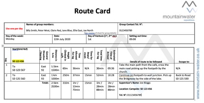
A route card is a document that is used by hillwalkers as an aid to navigation and route planning.
The planned route is broken down into discrete sections termed “legs” or “stages”. Whenever possible, each leg will start and finish at a clearly defined topographical feature such as a lake, knoll, saddle, stream junction and so on. In most cases the legs are defined as being the longest section that might be safely followed on a single compass bearing. The object is to split the overall route into sections that can be readily undertaken in conditions of poor visibility such as in cloud, fog or at night.
In addition to the compass bearing, for each leg the total distance will be measured as well as the height gained or lost and the steepness of the ground. Using this information an estimated time to complete the leg will be calculated usually using Naismith’s Rule or one of its variations. These times are then added to estimate the total time needed for the expedition.
For each leg note may also be taken of potential sources of danger along the route such as cliffs or of handrail/collecting features to aid in confirming the route.
Parts that make up route cards
- Leg – Your daily route should be broken down into bite size parts. Each of these parts become a leg
- Grid Reference – Each leg should start with a six-figure grid reference
- General Direction – Each of our legs should have a general direction. If any part of that leg has a difficult section, we may think about doing a bearing to help us along with our navigation for that part of the leg
- Distance – Each of our legs should have an overall direction in meters or Kilometres
- Height Climbed – For each leg we should work out the overall height in meters climbed
- Time allowed for leg – For the given leg we should work out a time
- Time allowed for stops – Anytime allowed for stopping should be record
- Over time for leg – Time allowed + Time for breaks = Overall time
- Details of route – This is the part were we tell the story of the leg. What features we will be passing etc.
- Escape Route – How to get to safety if thing go wrong for that part of the leg
The process of completing the route card is very simple it just becomes time consuming when we have multi day routes to record such as would be for a Gold DofE expedition but we must remember a route card is a safety measure and should be completed before setting out on the journey.
The route card, along with a copy of your corresponding map, should be given to a trusted adult leader who is not going on the trip. The points of your route card should match with the route on your map, based on the map’s longitude/latitude grid lines.
There are a number of other purposes of having route card:
- structure for planning your day in the hills, including the route
- details of who’s in the group and their emergency points of contact
- record of kit carried, including maps
- enable you to keep track of progress v schedule during the day
- alternative & escape routes shown
- your intentions are known should you fail to return on time
Mountain Water Expeditions is a DofE Approved Activity (AAP) for the Expedition section at all three levels of the award and also the DofE residential section at gold level.
We have over thirty years of experience of working with schools, colleges and other community-based groups providing DofE expeditions of all levels in the UK and overseas.
Mountain Water Expeditions has undergone external inspections from all the relevant authorities and has been successful in gaining an AALA license, DofE AAP licences for expeditions and the residential section and we hold the Learning Outside the Classroom Quality badge.
We are also approved to run leadership training from British Canoeing and Mountain Training and provide first aid training under the umbrella of Rescue and Emergency Care (REC).